The compass: Song needle, Mediterranean pivot, open winter (c. 1200)
A Song military manual floated an iron fish in 1044, Shen Kuo hung a rubbed needle on a silk thread in 1088, Guangzhou pilots were steering by it in overcast by 1119 — and about 1190 an English schoolmaster at Paris described sailors doing exactly the same thing in the Channel, without saying where they had learned it. Within a century the Mediterranean had pivoted the needle in a box, drawn the sea to its bearings, and opened the winter; and the first thing its ships did in the Atlantic was take people.
Around 1190, in the notes of an English scholar teaching at Paris, sailors appear who, when cloud hides the sun and stars, touch a needle to a lodestone, float it, and watch it settle toward the pole. It is the method described in Kaifeng a century earlier and used at sea out of Guangzhou by 1119, and no source anywhere records who carried it west: the Persian and Arabic attestations come a generation after the Latin ones. What the Mediterranean did with the needle is better documented. By 1269 it was pivoted under a 360-degree circle; by 1290 the first portolan chart had drawn the whole sea to compass bearings, and Venetian convoys were making two round trips a year to the Levant instead of one. The first documented voyage a compass-steered ship made into the Atlantic, in 1341, came back to Lisbon with four Canary Islanders in the hold.
What the Mediterranean sailed by before the needle
The closed sea
In 1180, a merchant galley leaving Venice for Acre did so once a year, and it left in spring. That is not a preference; it is the structure of the receiving culture's maritime year, and every institution of the Mediterranean sea trade was built around it. The statutes of Venice, Pisa, Genoa and Ancona prohibited commercial sailing in the winter months — roughly from November to March — and while fleets under military necessity broke the prohibition often enough for John Pryor to call it a legal fiction, the commercial convoys observed it, because the reason for it was real 20. Between late autumn and early spring the Mediterranean sky is overcast for days at a time, the winds shift, and the daylight is short. A ship that could not see the sun by day or the pole star by night had no way of knowing which way it was pointing.
The consequence was a sailing season, and the sailing season set the tempo of everything. Frederic Lane's account of the Venetian convoy system before the 1280s is an account of one round trip a year to the Levant: out with the spring, back before the autumn closed the sea 18. A merchant's capital was tied up for a year. A cargo of pepper bought in Alexandria in June reached the Rialto in September and could not be replaced until the following summer. The whole rhythm of Mediterranean credit, insurance, fleet-building and diplomacy ran at that speed because the sea, for four months of the year, could not be crossed with confidence.
What the pilot had instead was memory. Mediterranean navigation in 1180 was coastal and experiential: a pilot knew headlands, the colour of the water off a river mouth, the run of a current past a cape, the bearing of a mountain at dawn. The written form of that knowledge was the portolano, a list of places along a coast with the distances and the wind-directions between them, descended from the periplus tradition of antiquity 19. Its directional vocabulary was the eight winds — Tramontana from the north, Greco, Levante, Scirocco, Ostro, Libeccio, Ponente, Maestro — and a pilot who had to describe a course said it in winds, not in degrees, because degrees were not something anyone at sea could measure.
The stone that pulled and did not point
The receiving culture knew the lodestone. It had known it since antiquity. Pliny describes the stone that draws iron; Augustine, in the City of God, describes a lodestone under a silver dish moving an iron ring above it, and finds it a wonder. But in the whole classical and early medieval Latin literature of the magnet there is not one sentence recording that a magnetised piece of iron will point in a fixed direction 816. The property that attracts was famous for a thousand years. The property that orients was not noticed, or not written down, until the last decade of the twelfth century.
That is the precise shape of the absence. Latin Europe in 1180 had the stone, had the iron, had needles on every ship, had the pole star as its fixed point, and had a commercial reason to want to sail in cloud. It did not have the idea that the first two objects, rubbed together, would find the fourth. Every physical component of the mariner's compass existed in the Mediterranean before the compass did.
The sea beside it
The Indian Ocean, on the other side of the Islamic world, sailed differently and did not have the compass either. Arab and Persian navigators ran the monsoon with the stars: the altitude of the pole star above the horizon, measured with the fingers or with the knotted cord of the kamāl, gave latitude, and the monsoon gave the direction and the season 8. It was a sophisticated system and a seasonal one. Petra Schmidl, surveying the whole Islamic record in 1997, found no reference to the magnetic compass in any Arabic or Persian source before the 1230s 8. The Indian Ocean was joined to the South China Sea by a continuous shipping lane through the Straits of Malacca on which Chinese and Muslim vessels had been meeting since the Tang; the needle was on one end of that lane by 1119, and there is no record of it on the other for another century.
So the receiving culture's position in 1180 can be stated in five parts:
- The sea closed for a third of the year, by statute and by the real hazard of sailing without a fixed reference in cloud.
- One round trip a year was the tempo of the Levant trade, and capital, credit and fleet size were all scaled to it.
- The pilot's memory and the written portolano were the only instruments of direction, and both spoke in eight winds.
- The lodestone was known and its directive property was not — the components were present and the idea was absent.
- The neighbouring Islamic sea had its own star-based system and no compass either, which matters for every claim about who carried what to whom.
A needle in a bowl of water
Kaifeng, 1044 and 1088
The first unambiguous description of a magnetic direction-finder is in a military manual. The Wujing zongyao, compiled at the Northern Song court under Zeng Gongliang and completed in 1044, describes a south-pointing fish for troops marching in dark weather: a leaf of thin iron cut two inches long and half an inch wide, pointed at head and tail, heated red in a charcoal fire, held with its tail toward north, and quenched — after which, floated in a bowl of still water, its head points south 2. The physics is thermoremanence in the earth's field, which no one in Kaifeng knew; the practice worked, and the text pairs it with the old mechanical south-pointing chariot as an equivalent aid. Barbara Kreutz, writing from the Mediterranean side in 1973, calls this the first incontrovertible mention of a magnetic device used for establishing direction anywhere 17.
Forty-four years later Shen Kuo, retired from a career that had included the directorship of the astronomical bureau, set down in the Mengxi bitan the passage on which the entire history of the compass as an instrument rests 3. It is short enough to give whole:
Magicians rub the point of a needle with lodestone; then it can point south. But it always inclines slightly to the east and does not point due south. Floated on water it wobbles a good deal. It can be set on a fingernail or on the rim of a bowl, where it turns more freely, but being hard and smooth it easily falls off. It is best to suspend it by a thread: take a single cocoon filament from new silk floss, fix it to the waist of the needle with a mustard-seed's worth of wax, and hang it where there is no wind; then the needle always points south. Among such needles some, after rubbing, point north. In my household we have both kinds. That the lodestone points south, like the cypress leaning west, no one can explain.
Four mounting methods; the observation that the needle does not point true, which is the first record of magnetic declination anywhere and would not be made in Europe for another four centuries 1; and a note that both polarities occur. Needham, tabulating eighteen Chinese declination observations from the eighth century to the nineteenth, established that the credit for the discovery belongs to China and that Shen Kuo's is the earliest clear statement of it 1. Wang Zhenduo's three-part study in the Kaogu xuebao between 1948 and 1951 remains the standard Chinese account of the sequence from the Han lodestone spoon to the Song needle 6.
Guangzhou, 1119: the needle goes to sea
Shen Kuo's needle was a household curiosity and a geomancer's tool. Its first recorded use at sea is in a book of anecdotes by a man whose father had run the port. Zhu Fu was Superintendent of Merchant Shipping at Guangzhou from 1094 to 1099; his son Zhu Yu wrote up what he had learned there in the Pingzhou ketan, finished in 1119 4. The passage on the ocean junks is matter-of-fact:
The pilots know the geography. By night they observe the stars, by day the sun, and in overcast weather they observe the south-pointing needle; or they lower a hook on a line of ten zhang, bring up mud from the seabed and smell it, and so know where they have come to.
Three things are worth noticing. The needle is one aid among four, and it is the aid for bad weather. It is described as routine, on ships sailing between Guangzhou and the ports of Southeast Asia, which means the practice is older than the book. And the ships in question carried crews of several hundred; this is not a fisherman's trick but the equipment of the largest merchant vessels then afloat 47.
Five years later the needle appears in an official's travel record. Xu Jing, a member of the Song embassy to Goryeo in 1124, described in the Xuanhe fengshi Gaoli tujing the night crossing of the Yellow Sea, when the ship could not stop and steered by the stars and the Dipper, and when the sky was dark used the floating south-pointing needle to establish north and south 5. By the early twelfth century, then, the Chinese needle is documented on the southern trade route and on the northern embassy route, floated in water, used in overcast, pointing south. Sun Guangqi's history of Chinese navigation traces from here the later development of the zhenlu — the needle-route, a written course in compass bearings that made the Ming rutters possible 7.

The Islamic record, 1232 to 1290
The earliest secure reference to the compass in the Islamic world is Persian, and it is later than the earliest Latin one. In the Jawāmiʿ al-ḥikāyāt, an anthology compiled by the writer ʿAwfī in the Delhi Sultanate around 1232, an incident is told of a voyage in the Red Sea or the Persian Gulf, dated to 1232–33: a fish made of iron is rubbed with a lodestone and put into a bowl of water, where it rotates until it stops pointing south 89. The device is a fish, as in the Wujing zongyao; it floats, as in every Chinese description; and it points south, which is the Chinese convention and not the one any Latin writer uses. Schmidl, who assembled the Islamic evidence, describes the incident and does not draw the inference. The inference is there to be drawn, and the record should be honest that it is an inference.
The first full description of nautical use in Arabic is by the Egyptian mineralogist Baylak al-Qibjāqī, in the Kitāb Kanz al-tujjār fī maʿrifat al-aḥjār, a treatise on stones written in 1282. He describes what he saw on a ship sailing from Tripoli in Syria to Alexandria in 1242–43: an iron needle joined crosswise to a rush and set on a bowl of water; a lodestone brought close and the hand holding it moved in a circle above; the needle following; the stone withdrawn, and the needle settling on the meridian 810. He adds that on the Indian Ocean captains used a hollow fish of sheet iron instead. Schmidl notes that Baylak says nothing about the nationality of the vessel, and quotes Soucek's judgement in the Encyclopaedia of Islam that the instrument was little used by Arab seafarers in the Mediterranean and that its Arabic name is a Latin borrowing 8.
The compass also went somewhere in the Islamic world it went nowhere else. Around 1290 the Rasulid sultan al-Ashraf ʿUmar of Yemen, an astronomer-prince, wrote a treatise describing a floating needle-and-rush compass and its use to find the qibla, the direction of Mecca — the earliest known evidence, in Schmidl's edition, of the instrument being turned to the sacred direction 8. The same object that was a pilot's bad-weather aid in Guangzhou and, within a decade, a chart-maker's grid in Genoa was in Taʿizz an instrument of prayer.
The Latin record, c. 1187 to 1269
The earliest European references are three, they are close together, and every one of them describes the Chinese method.
Alexander Neckam, an English scholar teaching at Paris and later abbot of Cirencester, wrote in the De naturis rerum about 1187–1190 that the sailors, as they sail over the sea, when in cloudy weather they can no longer profit by the light of the sun, or when the world is wrapped in the darkness of night, and they do not know to what point their ship's course is directed, touch the magnet with a needle, which is whirled round in a circle until, when its motion ceases, its point looks direct to the north 1112. His De utensilibus, a schoolroom vocabulary, lists the needle among a ship's equipment as if it were as ordinary as the anchor. He describes it as something sailors do. He does not describe it as new.
Guyot de Provins, a Cluniac monk and former trouvère, put the needle into a satirical poem, the Bible, composed between 1203 and 1208 — sailors rub a needle on an ugly brownish stone, set it on a straw in water, and when the sea is dark and murky and neither star nor moon can be seen, they bring a light to the needle and have no fear of losing their way, for the point goes toward the star 13. Jacques de Vitry, bishop of Acre, wrote in the Historia Orientalis around 1219–1221 that an iron needle, after it has touched the adamant, always turns toward the north star, which like the axis of the firmament does not move while the others turn, and that this is therefore very necessary to those who sail the sea 14.
A rubbed needle, floated on a straw or through a cork in a bowl of water, used in cloud, pointing at the pole star. That is the Chinese object with the Chinese method and the opposite naming convention — the Latin writers say north where the Chinese say south, which is a matter of which end you name and not of which way the needle lies.
The European instrument, as distinct from the European needle, is first fully described sixty years later, in a letter. Petrus Peregrinus de Maricourt, a Picard in the army of Charles of Anjou besieging Lucera in Apulia, wrote to his friend Sygerus of Foucaucourt on 8 August 1269 the Epistola de magnete 15. Its first part is an experimental account of the lodestone's poles, which he identifies and names, and which he argues derive their virtue from the poles of the heavens rather than from the pole star. Its second part describes two instruments. The first is a lodestone floated in a wooden bowl for finding the meridian. The second is the thing that matters: a needle set on a thin axis of brass or silver pivoted at the centre of a vessel, under a cover divided into four quarters and each quarter into ninety parts — a full circle of 360 degrees — with a ruler across it for taking bearings 15. Julian Smith's survey of the European literature argues that most of what Peregrinus records was already known, and that his achievement is one of organisation rather than discovery 16. That is fair, and it leaves his description of the pivoted, graduated needle as the first written record of the dry compass in any language.
What the sources say, and what they do not
Because this record's whole subject is a lineage whose middle is disputed, the attestations are best set down in order:
| Year | Where | Source | What is described |
|---|---|---|---|
| 1044 | Kaifeng | Wujing zongyao | iron fish, heated and quenched, floated; points south |
| c. 1088 | Runzhou | Shen Kuo, Mengxi bitan | rubbed needle; four mountings; declination; points south |
| 1119 | Guangzhou | Zhu Yu, Pingzhou ketan | needle used at sea in overcast |
| 1124 | Yellow Sea | Xu Jing, embassy record | floating needle on the Goryeo crossing |
| c. 1187–90 | Paris / St Albans | Alexander Neckam | rubbed needle, whirled and settles; points north |
| c. 1203–08 | Provins | Guyot de Provins | needle on a straw in water; points to the star |
| c. 1219–21 | Acre | Jacques de Vitry | needle touched to adamant turns to the north star |
| 1232–33 | Red Sea or Gulf | ʿAwfī, Persian anthology | iron fish rubbed and floated; points south |
| 1242–43 (written 1282) | Tripoli to Alexandria | Baylak al-Qibjāqī | needle-and-rush cross floated; Indian Ocean iron fish |
| 1269 | Lucera | Petrus Peregrinus | pivoted needle under a 360-degree circle |
| c. 1290 | Yemen | Sultan al-Ashraf | floating compass used to find the qibla |
What is certain. The magnetised needle as a direction-finder is Chinese, documented from 1044 and 1088. Its use at sea is Chinese, documented from 1119. Every early Latin description is of a floating rubbed needle, which is the Chinese method. The pivoted needle under a graduated circle is first described in Latin, in 1269 123415.
What is strongly supported. The route existed and carried other things. Paper, gunpowder and printed paper money all travelled this corridor in the same centuries, and Chinese and Muslim ships were meeting in the Straits of Malacca throughout 1. The Persian fish of 1232 is Chinese in form and in convention 89.
What is contested. Whether the Mediterranean needle came from China at all, and if so by what hands. Julius Klaproth, in an open letter to Alexander von Humboldt in 1834, argued from the Chinese and Arabic texts for Chinese invention and diffusion through the Arabs to the West 21. Needham, a century and a quarter later and with far more of the Chinese record in hand, took Chinese priority as settled and westward transmission as probable, while conceding that the Arabic references post-date the Latin ones and that no carrier can be named 1. Kreutz turned the question round: whatever the origin of the floating needle, the instrument — the dry pivot, the card, the sixteen- and then thirty-two-point rose — was, she argued, a Mediterranean development, and the interesting history is there 17. Li Shu-hua's two-part study in Isis in 1954 and Albert Schück's three-volume Der Kompass of 1911–18, with its chapters on the legends of invention, are the earlier scholarly poles of the same argument 2223.
What is not supported. Any document naming a person, a ship or a text that carried the needle west. Nothing in Neckam, Guyot or Vitry says where sailors learned it. Nothing in ʿAwfī or Baylak says where their captains learned it. The Latin chronology is a generation ahead of the Islamic chronology, which is the reverse of what the three-node story requires, and Schmidl, having laid the evidence out more completely than anyone, declines to rule 8. So does this record.
What the needle changed, and what it displaced
From needle to instrument
Between Peregrinus in 1269 and about 1300, the Mediterranean turned a needle into a machine. The needle was fixed to a card; the card was pivoted on a pin; the pin stood inside a round boxwood case — the bussola, from the Latin buxula, a little box of buxus, which is why every Romance language still calls the compass a box 17. The eight winds became sixteen and then thirty-two points, and the north point acquired the fleur-de-lis that marks it on every rose since. Kreutz's article is largely a reconstruction of how and where these steps happened, and her conclusion is that they are Mediterranean, probably Italian, and unrecorded in any dated text 17. What can be said is that a Chinese needle floated in water and a European card pivoted on a pin are different objects in the hand, and that the second is the one the Atlantic would be crossed with.
The name that Europe eventually attached to this step is a fiction, and it is worth telling exactly, because it shows how a receiving culture manufactures an inventor when it does not have one. About 1450 Flavio Biondo, in his Italia illustrata, wrote that the use of the magnet in navigation was credited to the Amalfitans. In 1511 the Bolognese scholar Giambattista Pio repeated it in Latin: Amalphi in Campania veteri magnetis usus inventus, a Flavio traditur — at Amalfi in Campania the use of the magnet was invented, as Flavio (Biondo) reports. Later writers moved the comma, so that the invention was by Flavio; Flavio became an Amalfitan; and a surname, Gioia, was found for him. A bronze of Flavio Gioia, inventor of the compass, was raised in Amalfi's harbour square in 1900 and stood there through the twentieth century 1722. No such man existed. The city that has the best documentary claim on the Mediterranean compass — through the Carta Pisana, through Vesconte, through the Vivaldi — is Genoa, and Genoa never claimed to have invented it.
The chart that could only exist with a compass
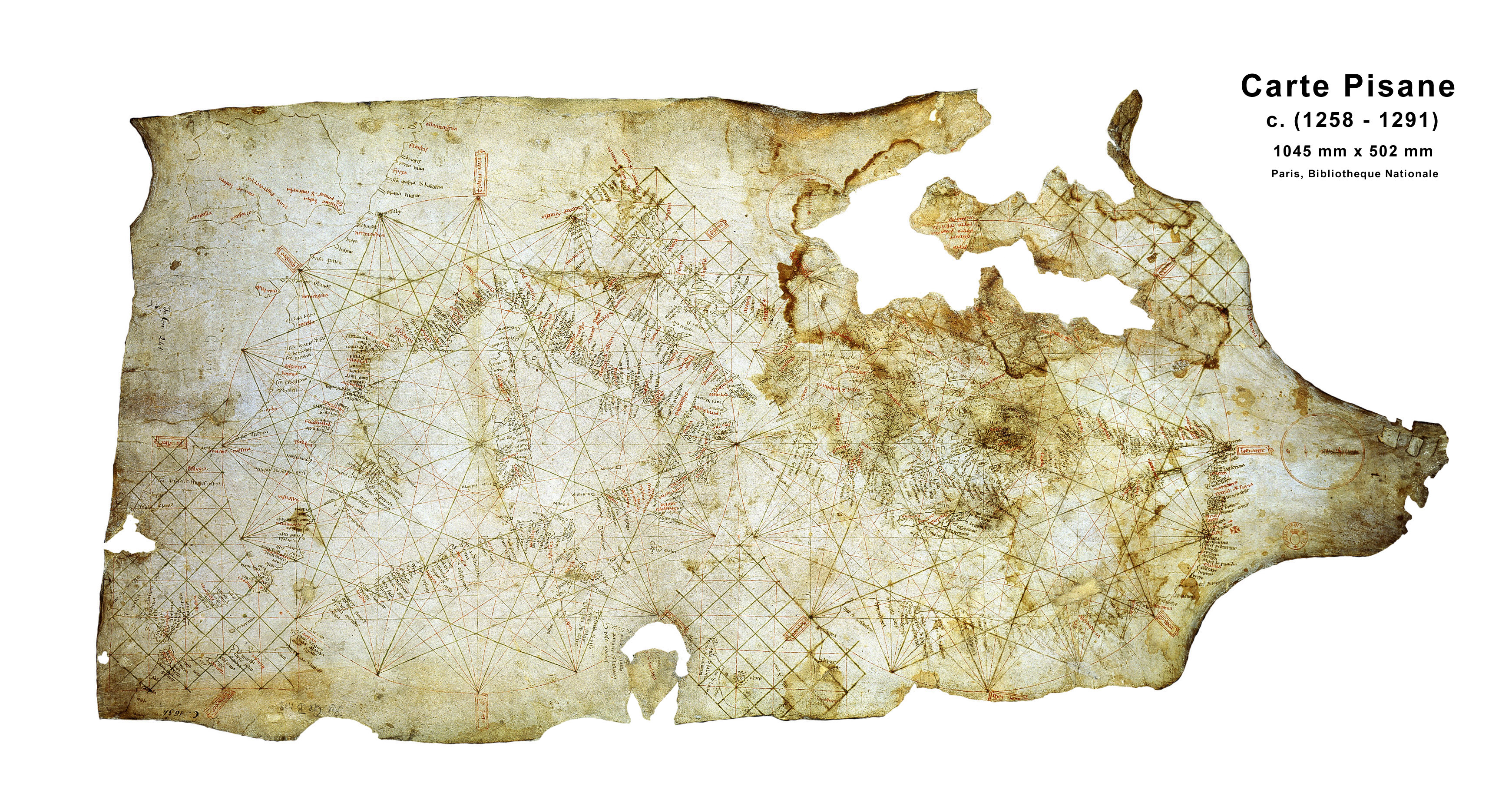
The portolan chart appears in the same decade as the pivoted compass, and it cannot exist without it. Tony Campbell's survey for the History of Cartography describes the earliest survivor, the Carta Pisana, now in the Bibliothèque nationale de France, as a chart of the whole Mediterranean drawn in the last decades of the thirteenth century — most scholars say at Genoa — with no known ancestor and every characteristic of the charts that followed it 19. Its coastline is startlingly accurate. Its surface is ruled by a web of lines radiating from hidden centres in sixteen directions: the winds of the compass, drawn so that a pilot laying a straightedge from his port to his destination could read the bearing off the nearest rhumb. The chart is a compass rose the size of a sea. It could not have been compiled without hundreds of compass bearings taken between ports, and it could not have been used without a compass on board to steer them.
The earliest signed and dated chart is Pietro Vesconte's, Genoese, made in 1311 and now in the Archivio di Stato at Florence; the first compass rose actually drawn on a chart, with its fleur-de-lis, is on the Catalan Atlas of 1375 19. Between those dates the chart and the instrument became a single working system, and a third element joined them: the arithmetic of the traverse. Ramon Llull, asking in the Arbor scientiae of 1295 how sailors measure miles at sea, answers that they have an instrument, a chart, a compass, a needle and the star of the sea — instrumentum, chartam, compassum, acum et stellam maris — and that the instrument lets a ship that has been driven off its course calculate how far it has advanced along it 19. The toleta de marteloio, the trigonometric table that does exactly that, survives in Andrea Bianco's atlas of 1436, but Llull has it, or something like it, in 1295. Compass, chart and table: by 1300 the Mediterranean had the three-part navigational system it would carry into the Atlantic.
The winter opened
Lane's 1963 article is the economic argument, and it turns on a date. The opening of the seas in winter, he wrote, about 1280 or 1290, together with the safer crossing of the Bay of Biscay, point to the most important part of the invention having been made shortly before those dates 18. The additional months were of considerable economic importance: they enabled the Venetian convoys to make two round trips a year to the Levant instead of one 18. That doubling is the whole point. The compass did not make the sea any smaller. It made the year longer, and a merchant whose capital turned twice was a different kind of merchant from one whose capital turned once.
The other edge of the change was the Strait of Gibraltar. From 1277 Genoese galleys were sailing through it and up the Atlantic coast to Flanders and England, a voyage that crosses the Bay of Biscay in open water where the coast-following pilot has nothing to follow 1825. The Atlantic voyage of the Mediterranean ship begins in the same decade as the winter voyage and for the same reason. What follows in the Atlantic — the Vivaldi, the Canaries, and everything after — is a consequence of a needle in a box.
What was displaced
The list of what the instrument pushed aside is longer than the usual account:
- The closed season. Not abolished — the statutes stayed on the books — but broken as the norm of commercial sailing. By the 1290s the winter voyage was ordinary 1820.
- The pilot's memory as the sole instrument of direction. It remained essential, but it now had a rival that could be written down, bought, and carried by someone else.
- The eight winds. The mental compass of the portolano gave way to sixteen and then thirty-two points, and the language of bearings was standardised across the sea 1719.
- The written coast-list as the pilot's chart. The portolano survived, but as a companion to a drawn chart on which position could be plotted rather than recited 19.
- The Chinese object itself, in its new home. Europe took the floating needle and within a century abandoned it for the dry pivot. China did not: the water compass remained the Chinese mariner's instrument into the eighteenth century, and the one in the National Maritime Museum at Greenwich, made about 1760, is still a needle floated in a bowl 17.
- The south. The Chinese needle points south; the European needle points north. Nothing about the iron changed. The end that was named did, and the naming that won is the one on every map since.
The bill
1291: the ships that did not come back
In May 1291 two galleys left Genoa under Vandino and Ugolino Vivaldi, fitted out with the backing of Tedisio Doria, carrying two Franciscan friars, and bound, as the Genoese annalist Jacopo Doria recorded, for India by the Ocean Sea 25. They passed the Strait and were last seen off the Moroccan coast near Cape Nun. Nothing more was heard of them. Felipe Fernández-Armesto's account of the Mediterranean's first Atlantic century begins with them because they are the first documented attempt to use the Mediterranean ship and its new instruments to go round Africa, and because their disappearance did not stop anyone 25. It is not an item on the bill. It is the date the bill opens.
1341: four people in a ship's hold
On 1 July 1341 three ships sailed from Lisbon under a Genoese captain, Nicoloso da Recco, and a Florentine, Angiolino del Tegghia de' Corbizzi, with the licence of Afonso IV of Portugal and a mixed crew of Italians, Portuguese and Castilians. They spent five months in the Canary Islands. What they brought back is known because a Florentine merchant's letter reporting the voyage was copied out by Giovanni Boccaccio, and survives as the De Canaria: goat skins, tallow, dyestuff, and four men taken from the islands 2425. The four were shown in Lisbon. They spoke a language nobody could place, and Boccaccio's text is the first reliable record of it.
That is the first documented act of the Atlantic compass. Not a route to India, not a spice, not a map; a raid, with people in the hold, on an archipelago that could be reached from Lisbon and returned from only by a ship that could hold a course across open water for days. It is worth being precise about the technical dependence. The Canaries lie a hundred kilometres off the African coast at their nearest, and the return to Iberia against the prevailing northeasterlies requires standing out into the ocean on a fixed bearing and coming back to the coast far to the north. The Vivaldi had shown that a Mediterranean ship could go. Recco showed that it could come back, and what it came back with was cargo of a particular kind.
1402 to 1496: the islands emptied
The conquest of the seven islands took ninety-four years. Jean de Béthencourt and Gadifer de la Salle took Lanzarote in 1402 under Castilian licence; Fuerteventura and El Hierro followed within the decade. The three large islands resisted for most of a century. Gran Canaria was invaded in 1478 by Juan Rejón, who founded Las Palmas, and reduced by Pedro de Vera, governor from 1480, whose campaign ended with the surrender of 29 April 1483. La Palma fell to Alonso Fernández de Lugo in 1492–93. Tenerife, the last, took Lugo two invasions: the first was destroyed at Acentejo on 31 May 1494, and the second, in 1495, succeeded 2526.
Between the two came the modorra. In the winter of 1494–95, an epidemic — Fray Alonso de Espinosa, writing in 1594, says so great a pestilence came that almost all were dying of it, and it was the modorra — went through the Guanche population of Tenerife while the Castilian soldiers, who were immune, were untouched 27. The Instituto Canario de Bioantropología's reconstruction from the chronicles identifies it as influenza, puts Tenerife's population at the conquest at 20,000 to 25,000, and estimates the dead at 4,000 to 8,000 — between a fifth and a third of the island, in a single season 27. Lugo's second campaign marched through the survivors.
Igor Pérez Tostado's chapter in the Cambridge World History of Genocide states the outcome without qualification. The conquest was carried mostly by private adventurers backed by the legal rights of the Castilian crown and supplied by private financiers who expected a quick return, and it brought the destruction of the native population of all the islands — the erasure of their names, language, custom, economy, land ownership, ecological environment, beliefs, culture, social structure and political organisation. The means by which it was achieved were enslavement, deportation, disease, and the strategic use of terror 26. Captives from the islands were sold in the slave markets of Seville and Valencia; the survivors who converted were put to work on the sugar plantations that were the islands' first export industry, and the plantations were then worked by enslaved Africans when the islanders ran out 2526.
Alfred Crosby's phrase for the Canaries was a pilot programme, and Pérez Tostado's chapter is in effect the audit of it: the archipelago was where the Iberian crowns learned how an island of people could be turned into an island of sugar 26. The compass did not do that. The compass is what put the archipelago inside a sailing season from Lisbon and Seville, and the atlas's rule is that a transmission pays for what it did. What it did, first, was this.
The winter trade in people
The other line on the bill is closer to home and harder to see, because it is a rate rather than an event. Lane's two round trips a year applied to every cargo the Venetian and Genoese convoys carried, and one of the cargoes out of the Black Sea after the Genoese established themselves at Caffa in 1266 was people. Hannah Barker's study of the Mediterranean trade in Black Sea slaves — Tatar, Circassian, Russian and other captives sold through Caffa and Tana to Italian households and, in far larger numbers, to the Mamluk sultanate — draws its demographic figures from the Genoese notarial archives, and one of them is this: enslaved people were one to two per cent of Genoa's population in the thirteenth century and four to five per cent in the fifteenth 28. The trade had many drivers, and the compass is not the largest of them. But a trade that depends on the number of voyages a year is amplified by anything that doubles the number of voyages a year, and the winter galley out of Caffa carried what the summer galley carried.
What is billable here, and what is not
The transmission itself killed no one. There is no siege in this record, no deportation at the moment of transfer, no epidemic, and no documented moment of transfer at all. Records like this one are where the temptation to inflate is strongest — one could hang the entire Atlantic system on a needle — so the accounting should be explicit.
Billed here. The Canary Islands, from the four men in Recco's hold in 1341 to the surrender of Tenerife in 1496: the first thing the compass-equipped Atlantic ship did, and the rehearsal for everything after. The amplification, not the existence, of the Black Sea slave trade by year-round sailing. And a small item that belongs on the bill anyway: the manufacture of a European inventor for a Chinese object, and the statue to him.
Not billed here. The Atlantic slave trade proper. On 8 August 1444 Lançarote de Freitas landed 235 captives from the Mauritanian coast at Lagos, and Gomes Eanes de Zurara, who was there, describes them being divided into five lots on a field outside the town while Prince Henry, on horseback, took forty-six as his fifth 29. That morning is the visible edge of what this record is not charging for; it belongs to the caravel and to the Portuguese crown, and it is named here so that the omission is a choice and not an oversight. Columbus, and the demographic catastrophe of the Americas, are likewise not billed: a transmission pays for what it did, not for everything that happened afterwards in its vicinity.
Why the rating is 2 and not lower. Because the first documented Atlantic voyage by a compass-steered ship came home with human cargo, and the archipelago it raided was destroyed as a people within a century and a half by the same ships from the same ports. Why it is 2 and not higher. Because the instrument's own transmission was bloodless, because the compass is one of several conditions of the Atlantic and not its cause, and because the atlas does not charge an eleventh-century needle for a fifteenth-century crown.
What followed
-
10441044: the Wujing zongyao, compiled at Kaifeng under Zeng Gongliang, describes a thin iron fish heated red, quenched with its tail to the north and floated in a bowl, its head pointing south — the first unambiguous magnetic direction-finder recorded anywhere, prescribed for troops marching in dark weather.
-
1088c. 1088: Shen Kuo, in the Mengxi bitan, describes rubbing a needle on lodestone, four ways of mounting it, and the fact that it points slightly east of south — the earliest record of magnetic declination, four centuries before Europe noticed it.
-
11191119: Zhu Yu's Pingzhou ketan records that the pilots of the Guangzhou ocean junks steer by the stars at night, the sun by day and the south-pointing needle in overcast — the first documented use of the compass at sea, and described as routine.
-
11241124: Xu Jing, on the Song embassy to Goryeo, records that on the night crossing of the Yellow Sea the ship steered by the Dipper and, when the sky was dark, by the floating south-pointing needle.
-
1190c. 1187–1190: Alexander Neckam, teaching at Paris, writes in the De naturis rerum that sailors in cloud touch a needle to the magnet and watch it whirl and settle pointing north — the earliest European reference, describing an existing practice and not a new one.
-
1205c. 1203–1208: Guyot de Provins, in his satirical Bible, describes sailors rubbing a needle on an ugly brown stone, setting it on a straw in water, and steering by it toward the star when neither moon nor stars can be seen.
-
1220c. 1219–1221: Jacques de Vitry, bishop of Acre, writes in the Historia Orientalis that an iron needle touched to the adamant always turns to the north star and is therefore very necessary to those who sail the sea.
-
12321232–33: ʿAwfī's Persian anthology, compiled at the Delhi Sultanate, tells of a voyage in the Red Sea or Persian Gulf on which an iron fish rubbed with lodestone and floated in a bowl turned to point south — the earliest secure Islamic reference, Chinese in form and in convention.
-
12421242–43: on a ship from Tripoli in Syria to Alexandria, Baylak al-Qibjāqī watches a needle crossed with a rush floated on water and settled on the meridian by a lodestone moved above it; he writes it up in the Kanz al-tujjār in 1282 and adds that Indian Ocean captains use a hollow iron fish.
-
12698 August 1269: from the siege of Lucera, Petrus Peregrinus writes the Epistola de magnete, identifying the lodestone's poles and describing a needle pivoted on a brass axis under a cover divided into 360 degrees — the first written description of the dry compass.
-
1290c. 1290: the Rasulid sultan al-Ashraf ʿUmar of Yemen writes a treatise on the floating compass and its use to find the qibla, the direction of Mecca — the earliest evidence of the instrument turned to prayer.
-
1290c. 1290: the Carta Pisana, the oldest surviving portolan chart, is drawn — most scholars say at Genoa — with the whole Mediterranean ruled by rhumb lines in sixteen compass directions. About the same years, in Lane's account, the winter sea opens and Venetian convoys begin making two round trips a year to the Levant.
-
1291May 1291: the Vivaldi brothers sail from Genoa with two galleys for India by the Ocean Sea, pass the Strait, are last seen off Cape Nun, and are never heard of again.
-
13111311: the Genoese Pietro Vesconte signs and dates a portolan chart of the eastern Mediterranean — the earliest dated chart to survive. Ramon Llull had already written in 1295 that sailors measure miles at sea with an instrument, a chart, a compass, a needle and the star.
-
13411 July 1341: three ships leave Lisbon under Nicoloso da Recco and Angiolino del Tegghia de' Corbizzi, spend five months in the Canaries, and return with skins, tallow, dyestuff and four islanders — the first documented Atlantic slave-taking by a compass-steered ship, recorded in Boccaccio's De Canaria.
-
14448 August 1444: 235 captives from the Mauritanian coast are landed at Lagos and divided into five lots in Prince Henry's presence, forty-six going to him as his fifth. Zurara's chronicle records it; this record names it as the edge of what it does not charge for.
-
148329 April 1483: the Canarii of Gran Canaria surrender to Pedro de Vera after five years of war. Captives are sold in Seville and Valencia; converts are put to the sugar.
-
1495Winter 1494 to spring 1495: the modorra, probably influenza, kills an estimated 4,000–8,000 of Tenerife's 20,000–25,000 Guanches while the Castilian soldiers are untouched. Fernández de Lugo's second invasion goes through the survivors; the island submits in 1496 and the conquest of the archipelago is complete.
-
15111511: Giambattista Pio writes that at Amalfi the use of the magnet was invented, as Flavio Biondo reports. A moved comma later turns the reporter into the inventor, and a bronze of the non-existent Flavio Gioia is raised at Amalfi in 1900.
Where this lives today
References
- Needham, Joseph, with Wang Ling. Science and Civilisation in China, Volume 4: Physics and Physical Technology, Part 1: Physics. Cambridge: Cambridge University Press, 1962. Section 26(i), Magnetism and electricity. en
- 曾公亮、丁度等《武經總要》前集(Zeng Gongliang, Ding Du et al., Wujing zongyao, Collected Essentials of the Military Classics), 1044, the 指南魚 (south-pointing fish) passage. zh primary
- 沈括《夢溪筆談》卷二十四「雜誌一」(Shen Kuo, Mengxi bitan, Brush Talks from Dream Brook), c. 1088, the 磁石指南 passage. zh primary
- 朱彧《萍洲可談》卷二(Zhu Yu, Pingzhou ketan, Pingzhou Table Talk), 1119. zh primary
- 徐兢《宣和奉使高麗圖經》(Xu Jing, Xuanhe fengshi Gaoli tujing, Illustrated Account of the Xuanhe Embassy to Goryeo), 1124, juan 34, 海道. English translation: Sem Vermeersch, A Chinese Traveler in Medieval Korea. Honolulu: University of Hawaiʻi Press, 2016. zh primary
- 王振鐸「司南指南針與羅經盤——中國古代有關靜磁學知識之發現及發明」(上、中、下)《考古學報》第3、4、5冊,1948–1951。(Wang Zhenduo, The sinan, the south-pointing needle and the compass-dial: the discovery and invention of static magnetism in ancient China. Kaogu xuebao 3–5, 1948–51.) zh
- 孫光圻《中國古代航海史》北京:海洋出版社,1989。(Sun Guangqi, A History of Ancient Chinese Navigation. Beijing: Ocean Press, 1989.) zh
- Schmidl, Petra G. “Two Early Arabic Sources on the Magnetic Compass.” Journal of Arabic and Islamic Studies 1 (1997–98): 81–132. en
- ʿAwfī, Sadīd al-Dīn Muḥammad. Jawāmiʿ al-ḥikāyāt wa-lawāmiʿ al-riwāyāt, c. 1228–1233, the account of the iron fish; ed. and trans. in Schmidl 1997–98 and E. Wiedemann, Verhandlungen der Deutschen Physikalischen Gesellschaft 9 (1907). fa primary
- Baylak al-Qibjāqī. Kitāb Kanz al-tujjār fī maʿrifat al-aḥjār (The Merchants' Treasure on the Knowledge of Stones), 681 AH / 1282; the compass passage ed. Klaproth 1834, trans. J.-J. Clément-Mullet, Journal Asiatique, 6th ser., 11 (1868): 174. ar primary
- Neckam, Alexander. De naturis rerum libri duo, with De laudibus divinae sapientiae, edited by Thomas Wright. Rolls Series 34. London: Longman, 1863. Book II, chapter 98; and De utensilibus, ed. Wright in A Volume of Vocabularies (1857). la primary
- Bromehead, C. N. “Alexander Neckam on the Compass-Needle.” Terrestrial Magnetism and Atmospheric Electricity 50, no. 2 (1945): 139–140. en
- Guyot de Provins. La Bible, c. 1203–1208, lines on the marinette; ed. John Orr, Les œuvres de Guiot de Provins. Manchester: Manchester University Press, 1915. fr primary
- Jacques de Vitry. Historia Orientalis, c. 1219–1221, cap. 89 (on the adamant); ed. and French trans. Jean Donnadieu. Turnhout: Brepols, 2008. la primary
- Petrus Peregrinus de Maricourt. Epistola de magnete (Lucera, 8 August 1269). English: The Letter of Petrus Peregrinus on the Magnet, A.D. 1269, trans. Brother Arnold. New York: McGraw, 1904. la primary
- Smith, Julian A. “Precursors to Peregrinus: The Early History of Magnetism and the Mariner's Compass in Europe.” Journal of Medieval History 18, no. 1 (1992): 21–74. en
- Kreutz, Barbara M. “Mediterranean Contributions to the Medieval Mariner's Compass.” Technology and Culture 14, no. 3 (1973): 367–383. en
- Lane, Frederic C. “The Economic Meaning of the Invention of the Compass.” American Historical Review 68, no. 3 (1963): 605–617. en
- Campbell, Tony. “Portolan Charts from the Late Thirteenth Century to 1500.” In The History of Cartography, vol. 1: Cartography in Prehistoric, Ancient, and Medieval Europe and the Mediterranean, edited by J. B. Harley and David Woodward, 371–463. Chicago: University of Chicago Press, 1987. en
- Pryor, John H. Geography, Technology, and War: Studies in the Maritime History of the Mediterranean, 649–1571. Cambridge: Cambridge University Press, 1988. en
- Klaproth, Julius von. Lettre à M. le Baron A. de Humboldt, sur l'invention de la boussole. Paris: Dondey-Dupré, 1834. fr
- Schück, Albert. Der Kompass. 3 vols. Hamburg: self-published, 1911–1918. Vol. 2 (1915): Sagen von der Erfindung des Kompasses; Magnet, Calamita, Bussola, Kompass; die Vorgänger des Kompasses. de
- Li Shu-hua. “Origine de la boussole.” Isis 45, no. 1 (1954): 78–94; and “Origine de la boussole II: Aimant et boussole.” Isis 45, no. 2 (1954): 175–196. fr
- Boccaccio, Giovanni. De Canaria et insulis reliquis ultra Hispaniam in Oceano noviter repertis, c. 1342. Biblioteca Nazionale Centrale di Firenze, Banco Rari 50 (Zibaldone Magliabechiano), fols. 123v–124r. la primary
- Fernández-Armesto, Felipe. Before Columbus: Exploration and Colonization from the Mediterranean to the Atlantic, 1229–1492. Philadelphia: University of Pennsylvania Press, 1987. en
- Pérez Tostado, Igor. “The Spanish Destruction of the Canary Islands.” In The Cambridge World History of Genocide, vol. 1, edited by Ben Kiernan, T. M. Lemos and Tristan S. Taylor, 594–621. Cambridge: Cambridge University Press, 2023. en
- Rodríguez-Maffiotte Martín, Conrado, and Mercedes Martín Oval. “La ‘modorra’ o ‘moquillo’ de los guanches.” Instituto Canario de Bioantropología / Museo Arqueológico de Tenerife, Museos de Tenerife. es
- Barker, Hannah. That Most Precious Merchandise: The Mediterranean Trade in Black Sea Slaves, 1260–1500. Philadelphia: University of Pennsylvania Press, 2019. en
- Zurara, Gomes Eanes de. Crónica dos feitos notáveis que se passaram na conquista de Guiné por mandado do Infante D. Henrique, c. 1453, cap. 25. English: The Chronicle of the Discovery and Conquest of Guinea, trans. C. R. Beazley and E. Prestage. 2 vols. Hakluyt Society, 1896–99. pt primary